Lewis and Clark Expedition, Part 2: Thomas Jefferson’s Western Vision
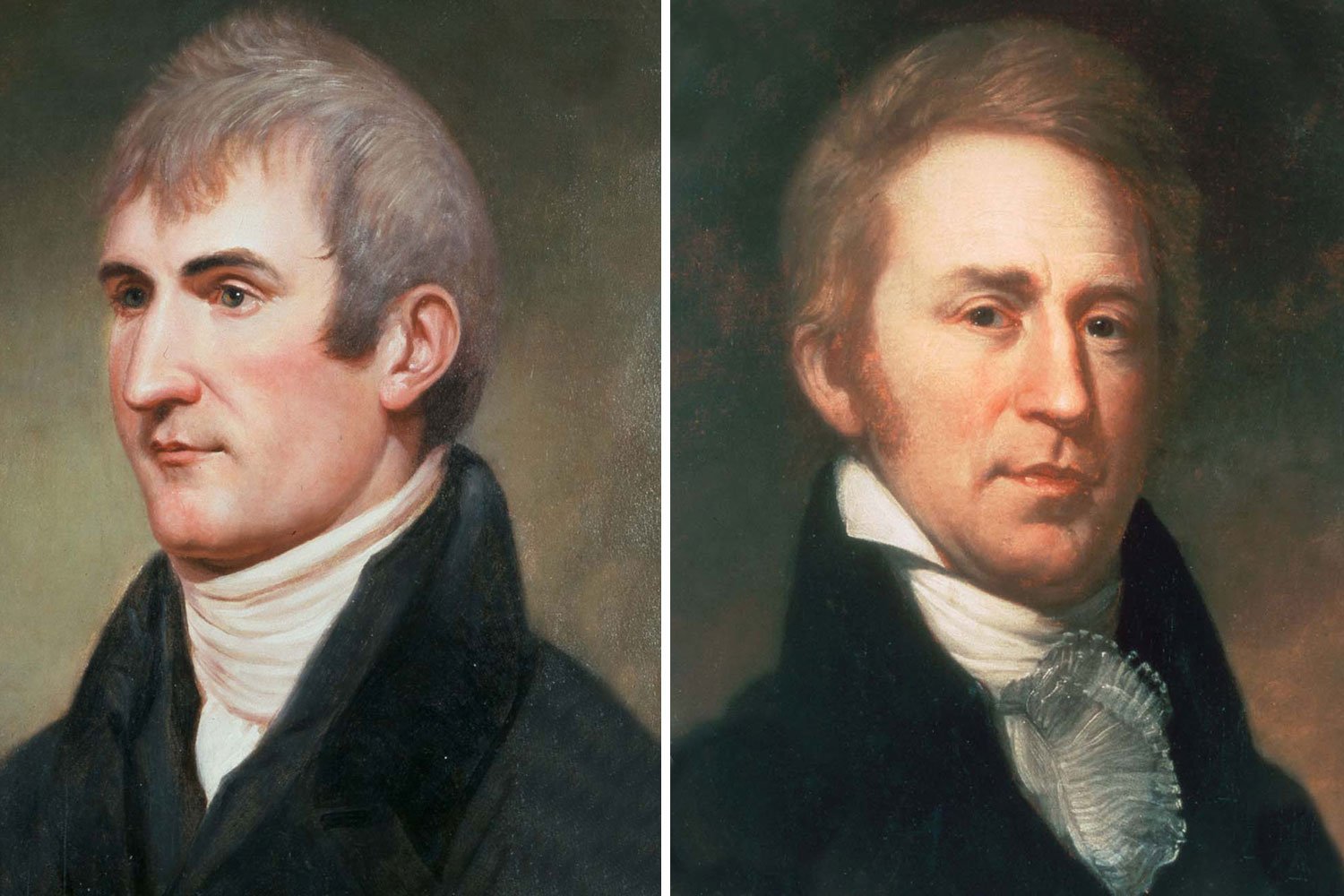
In 1803, President Thomas Jefferson drafted his official instructions for a great expedition to explore the Louisiana Territory and asked his private secretary, Captain Meriwether Lewis, to lead it. Once assembled, the Corps of Discovery would operate like a small frontier garrison with rigidly maintained discipline. In the end, the group went forward remarkably prepared for what they would encounter over the next few years, a testament to the thorough planning of President Jefferson.
Tom Hand, creator and publisher of Americana Corner, discusses Thomas Jefferson’s plan for western exploration, and why it still matters today.
Images courtesy of the National Gallery of Art, National Portrait Gallery - Smithsonian Institution, Library of Congress, Montana State Library, Smithsonian American Art Museum, Wikipedia, Wikimedia - Kbh3rd, National Park Service, WikiArt, Architect of the Capitol.
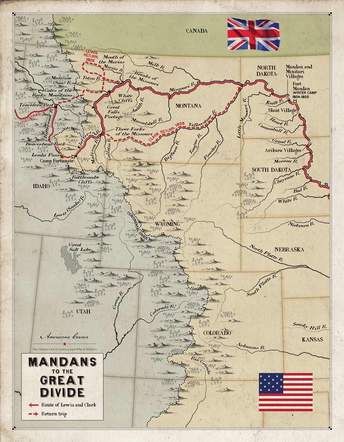
The Lewis and Clark Expedition had been traveling almost straight west and upstream since leaving the Mandan villages in early April 1805. They had safely made it to the west side of the Continental Divide, a great accomplishment, and now would be floating downstream on the western river system that would lead them to the Pacific Ocean.
Upon leaving the Great Falls of the Missouri on July 15, 1805, the Lewis and Clark expedition began to search in earnest for the Shoshone from whom they hoped to purchase horses for their journey over the Rockies. The next day, Lewis identified an abandoned but recent Shoshone camp with a wickiup and signs of numerous horses, but the Indians remained elusive. The captains decided to split up and have Clark take a detachment ahead while Lewis brought up the boats and the rest of the Corps.
As Lewis and Clark continued their journey up the Missouri River in 1805, the Corps was moving further and further from civilization with every stroke of their paddles. Although the Corps had been made aware of the countless wonders to the west through conversations with the Mandans and Hidatsas, it was quite another thing to observe the wonders for themselves, and at seemingly every bend in the river there were new discoveries.
The Corps of Discovery arrived at the Mandan villages near present day Bismarck, North Dakota, in late October 1804 and prepared to settle in for the long winter. For the past five months, the Lewis and Clark expedition had spent most days rowing or pushing their keelboat against the Missouri River’s powerful current, and the men were ready for a break. They were now 1,300 river miles upstream from the nearest civilized settlement and, although they did not know it, they had over 2,000 miles to go to reach the Pacific Ocean.
On August 31, 1803, Captain Meriwether Lewis departed from Fort Fayette, today’s Pittsburgh, in the keelboat the Corps of Discovery would take up the Missouri River and, six weeks later, arrived at the Falls of the Ohio and Clarksville, Indiana Territory. It was here, at the town founded by General George Rogers Clark, that Meriwether Lewis and William Clark, the General’s youngest brother, met again for the first time in seven years and commenced the most famous partnership in American history, two men so joined in American lore as to almost be inseparable.
In 1801, Meriwether Lewis was a Captain serving as the paymaster for the First Infantry Regiment of the United States Army. In March, he received a letter from Thomas Jefferson, the newly inaugurated President, asking Lewis to become his private secretary. Lewis, whose family was friends with the Jefferson clan, accepted at once, and thus began a close working relationship, one in which Jefferson became a father figure to Lewis and mentored his young subordinate on policy matters, including his dreams of western exploration and expansion.
By the time they began to assemble the Corps of Discovery in the summer of 1803, Thomas Jefferson and Meriwether Lewis knew more than anyone else about the Louisiana Territory, that immense wilderness the country had recently purchased from France. Although Jefferson had never ventured more than fifty miles west from Monticello, he had dreamed of the trans-Mississippi and studied the region extensively over the previous two decades, even trying unsuccessfully to send exploratory expeditions on several occasions.
The dream of finding an all water route across North America, the mythical Northwest Passage, had been imagined since the time of Christopher Columbus. Incredibly, three hundred years after the Admiral of the Ocean Seas completed his epic voyages, the vast interior of the continent was still essentially unknown to Europeans. This great uncertainty led to numerous theories about what lay beyond what men could see.
The Lewis and Clark Expedition sighted the Pacific Ocean, or more specifically the Columbia River estuary, on November 7, 1805, and spent the next month exploring the area and searching for a suitable location to build a fort for the coming winter. It was a wretched month, one of the worst of the entire journey, as the constant rain soaked the men and their equipment. But despite the conditions, the men felt a growing sense of pride as they considered their incredible accomplishments since leaving St. Louis in May 1804.